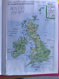
Landscape of The Lake District
This week the children were introduced to a topographic map and its key. They then used a topographic map of the United Kingdom to identify its landscape as well as zooming into The Lake District. The children enjoyed playing games to find places on the map and identifying that the north snd west of The United Kingdom are very hilly but the east and south are mainly flat, thus, there is a bigger population there.
Using knowledge from year three, they looked at how the mountains were formed (tectonic plates) and how glaciers could have formed the u shaped valleys found in the Lake District .


Comments
Post a Comment